Use the dropdowns to find the right kayaking tour for you
Type: basecamp
Minimum Age: 12, 6 on private tours
Relaxed
British Columbia, Canada
Blackfish Sound, British Columbia
CAD $2995*
- Private island retreat: relax, recharge and restore
- Oceanside hot tub ideal for whale-watching
- Large walk-in tents with beds and private bathrooms
- Diverse paddling in a wildlife-rich region
- Delicious meals prepared by our chef
Type: basecamp
Minimum Age: 12
Relaxed
British Columbia, Canada
Johnstone Strait
CAD $2295*
- Spectacular glamping in the heart of Johnstone Strait
- Wildlife viewing across from the renowned Robson Bight Ecological Reserve
- The ultimate camp for relaxing in the wilderness
- Oceanview hot tub & showers
- Scenic paddling & hiking opportunities
- Delicious, nourishing and fresh camp meals
- Large canvas tents with beds and linens
Type: basecamp
Minimum Age: 12
Relaxed
British Columbia, Canada
Johnstone Strait
CAD $2395*
- Comfortable glamping next to Johnstone Strait
- Opportunities to focus on your wellness goals
- Oceanview hot tub & shower
- Scenic paddling
- Delicious & filling meals
Type: expedition
Minimum Age: 12
Moderate
British Columbia, Canada
Johnstone Strait, Broughton Archipelago
CAD $2495*
- A classic expedition kayak route
- Experience the wildlife of Johnstone Strait
- Scenic paddling in the Broughton Archipelago
- Stunning remote campsites & one night at a floating lodge
- Watertaxi pickup to facilitate one-way expedition
Type: expedition
Minimum Age: 12
Moderate
British Columbia, Canada
Johnstone Strait and Blackfish Sound
CAD $1695*
- A big adventure on a smaller budget
- Paddle in the Johnstone Strait / Blackfish Sound region - the realm of the whales
- Scenic paddling with remote wilderness campsites
- Fantastic entry point to expedition paddling
Type: expedition
Minimum Age: 12
Moderate
British Columbia, Canada
Desolation Sound
CAD $1795*
- Spectacular Coast Mountain scenery
- Many islands and coastlines to explore
- Lake & ocean swimming opportunities
- Sheltered, warm waters
- A unique region best explored by kayak
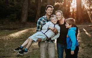
Type: family
Minimum Age: 5
Relaxed
British Columbia, Canada
Johnstone Strait and Blackfish Sound
CAD $2195*
- A family-friendly wilderness experience designed for families with children under 12
- Optimum flexibility and a great introduction to kayaking and the outdoors
- Child sized equipment provided
- Tasty food for both kids & adults
Type: expedition
Minimum Age: 12
Moderate
British Columbia, Canada
West Coast Vancouver Island
CAD $2495*
- Stunning West Coast scenery
- Sea otters and other coastal wildlife
- White sandy beaches
- Sea stacks and caves
- Gorgeous sunsets
Type: expedition
Minimum Age: 14
Most Adventurous
British Columbia, Canada
Great Bear Rainforest
CAD $3795*
- Paddle in the largest intact temperate rainforest in the world
- Protected inner passages and exposed coastlines
- Stunning scenery and sandy beaches
- Diverse wildlife
Type: mothership
Minimum Age: 12
Moderate
Chile
Chilean Patagonia
USD $12495*
- Explore the beautiful outer islands of southern Chile
- Stunning landscapes, hot springs, and glaciers
- Paddle at San Rafael Glacier amidst icebergs
- Private chartered mothership allows us to access remote areas in comfort
Type: mothership
Minimum Age: 12
Moderate
Chile
Chilean Patagonia
USD $17995*
- Expansive rugged wilderness and glaciers
- Rich wildlife including blue whales
- Private, remote hot springs
- Paddle in the wild and pristine Bahia Tic-Toc and the immense San Rafael Glacier
- Comfortable, mothership-based tour
Type: expedition
Minimum Age: 12
Moderate
The Bahamas
Exuma Cays
USD $2495*
- Explore the outer islands of The Bahamas
- Paddle among sandy cays, mangrove forests, and islands inhabited by iguanas
- Endless warm water snorkeling
- Wilderness beach campsites with beautiful surroundings and solitude
Type: Various - Private Groups
Minimum Age: 5
Various - tour depending
British Columbia, Chile, and The Bahamas
Various destinations around the world
CAD $USD*
- Private group tours
- Sea kayaking tailored to your group’s desires
- On base-camp tours, enjoy exclusive access to our campsites
- The ultimate flexibility and customization for your group
- Small groups & great guides
Type: expedition
Minimum Age: 12
Relaxed
Mexico
Baja Sur
USD $3850*
- Explore Isla Espiritu Santo Marine Park
- Paddle by towering cliffs and sandy beaches
- Endless snorkelling and sea life
- Comfortable beach campsites with beautiful surroundings and solitude
* Kayaking trips & tours that take place in Canada are priced and charged in Canadian dollars and are subject to 5% GST and $25 / person environmental sustainability fee. Trips & tours to destinations outside of Canada are priced and charged in US dollars and are subject to the $25 sustainability fee; there is no additional tax on tours that take place outside of Canada. Prices in other currencies can be estimated by clicking here. Please see our terms and conditions for full payment and fees information. "Family Friendly" indicates trip dates that welcome children under the minimum age of 12.
British Columbia Kayak Tours
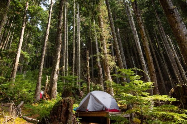
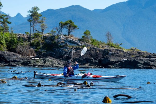
Choose from several of our professionally-guided 4-8 day BC kayak tours for all experience levels around Vancouver Island. Options include our glamping basecamp-style tours with oceanfront hot tubs overlooking the Pacific Ocean or our expedition-style paddling trips where you paddle from camp to camp. Our trips visit places like the Johnstone Strait, the Broughton Archipelago, the famous Desolation Sound, Nuchatlitz Provincial Park and the wild Great Bear Rainforest on the Central Coast of BC.
Type: basecamp
Minimum Age: 12, 6 on private tours
Relaxed
British Columbia, Canada
Blackfish Sound, British Columbia
From CAD $2995*
- Private island retreat: relax, recharge and restore
- Oceanside hot tub ideal for whale-watching
- Large walk-in tents with beds and private bathrooms
- Diverse paddling in a wildlife-rich region
- Delicious meals prepared by our chef
Type: basecamp
Minimum Age: 12
Relaxed
British Columbia, Canada
Johnstone Strait
From CAD $2295*
- Spectacular glamping in the heart of Johnstone Strait
- Wildlife viewing across from the renowned Robson Bight Ecological Reserve
- The ultimate camp for relaxing in the wilderness
- Oceanview hot tub & showers
- Scenic paddling & hiking opportunities
- Delicious, nourishing and fresh camp meals
- Large canvas tents with beds and linens
Type: basecamp
Minimum Age: 12
Relaxed
British Columbia, Canada
Johnstone Strait
From CAD $2395*
- Comfortable glamping next to Johnstone Strait
- Opportunities to focus on your wellness goals
- Oceanview hot tub & shower
- Scenic paddling
- Delicious & filling meals
Type: expedition
Minimum Age: 12
Moderate
British Columbia, Canada
Johnstone Strait, Broughton Archipelago
From CAD $2495*
- A classic expedition kayak route
- Experience the wildlife of Johnstone Strait
- Scenic paddling in the Broughton Archipelago
- Stunning remote campsites & one night at a floating lodge
- Watertaxi pickup to facilitate one-way expedition
Type: expedition
Minimum Age: 12
Moderate
British Columbia, Canada
Johnstone Strait and Blackfish Sound
From CAD $1695*
- A big adventure on a smaller budget
- Paddle in the Johnstone Strait / Blackfish Sound region - the realm of the whales
- Scenic paddling with remote wilderness campsites
- Fantastic entry point to expedition paddling
Type: expedition
Minimum Age: 12
Moderate
British Columbia, Canada
Desolation Sound
From CAD $1795*
- Spectacular Coast Mountain scenery
- Many islands and coastlines to explore
- Lake & ocean swimming opportunities
- Sheltered, warm waters
- A unique region best explored by kayak
Type: family
Minimum Age: 5
Relaxed
British Columbia, Canada
Johnstone Strait and Blackfish Sound
From CAD $2195*
- A family-friendly wilderness experience designed for families with children under 12
- Optimum flexibility and a great introduction to kayaking and the outdoors
- Child sized equipment provided
- Tasty food for both kids & adults
Type: expedition
Minimum Age: 12
Moderate
British Columbia, Canada
West Coast Vancouver Island
From CAD $2495*
- Stunning West Coast scenery
- Sea otters and other coastal wildlife
- White sandy beaches
- Sea stacks and caves
- Gorgeous sunsets
Type: expedition
Minimum Age: 14
Most Adventurous
British Columbia, Canada
Great Bear Rainforest
From CAD $3795*
- Paddle in the largest intact temperate rainforest in the world
- Protected inner passages and exposed coastlines
- Stunning scenery and sandy beaches
- Diverse wildlife
Type: Various - Private Groups
Minimum Age: 5
British Columbia, Chile, and The Bahamas
Various destinations around the world
From CAD $USD*
- Private group tours
- Sea kayaking tailored to your group’s desires
- On base-camp tours, enjoy exclusive access to our campsites
- The ultimate flexibility and customization for your group
- Small groups & great guides
* Kayaking trips & tours are priced and charged in Canadian dollars and are subject to 5% GST and $25 / person environmental sustainability fee. Please see our Terms and Conditions for complete terms. To check live availability on any trip, click the Book Now tab and select a trip date.
Chilean Patagonia Kayak Tours
Designed to offer the greatest range, flexibility and comfort possible in the wild southern waters of Chilean Patagonia, our mothership expeditions travel through the mainland fiords and island archipelagos of the Aysen Region. 12-day and 19-day Chile kayak tour itineraries make the most of your journey there and give you the opportunity to paddle a region that few adventurers are able to access.
Type: mothership
Minimum Age: 12
Moderate
Chile
Chilean Patagonia
From USD $12495*
- Explore the beautiful outer islands of southern Chile
- Stunning landscapes, hot springs, and glaciers
- Paddle at San Rafael Glacier amidst icebergs
- Private chartered mothership allows us to access remote areas in comfort
Type: mothership
Minimum Age: 12
Moderate
Chile
Chilean Patagonia
From USD $17995*
- Expansive rugged wilderness and glaciers
- Rich wildlife including blue whales
- Private, remote hot springs
- Paddle in the wild and pristine Bahia Tic-Toc and the immense San Rafael Glacier
- Comfortable, mothership-based tour
* Kayaking trips & tours to destinations outside of Canada are priced and charged in US dollars and subject to a $25 / person environmental sustainability fee. Prices in other currencies can be estimated by clicking here. There is no additional tax on tours to international destinations. Please see our terms and conditions for full payment and fees information.
The Bahamas Kayak Tours
Longing for a warm water getaway in the winter? Daydreaming of paddling sparkling azure waters fringed with white sand beaches under a brilliant blue sky? Our Exuma Cays kayak expeditions are just the thing to banish the winter blahs with self-supported, camp-to-camp subtropical kayak trips.
Type: expedition
Minimum Age: 12
Moderate
The Bahamas
Exuma Cays
From USD $2495*
- Explore the outer islands of The Bahamas
- Paddle among sandy cays, mangrove forests, and islands inhabited by iguanas
- Endless warm water snorkeling
- Wilderness beach campsites with beautiful surroundings and solitude
* Kayaking trips & tours to destinations outside of Canada are priced and charged in US dollars and subject to a $25 / person environmental sustainability fee. Prices in other currencies can be estimated by clicking here. There is no additional tax on tours to international destinations. Please see our terms and conditions for full payment and fees information.
Baja Glamping and Kayaking
Have you always dreamed of kayaking the beaches and desert shorelines of the Sea of Cortez? Does the thought of viewing grey whales in their winter calving grounds on Baja's Pacific Coast fill you with joy? Our Baja kayak trips are just what you need to find that winter escape that fills your bucket at the same time.
Type: expedition
Minimum Age: 12
Relaxed
Mexico
Baja Sur
From USD $3850*
- Explore Isla Espiritu Santo Marine Park
- Paddle by towering cliffs and sandy beaches
- Endless snorkelling and sea life
- Comfortable beach campsites with beautiful surroundings and solitude
* Kayaking trips & tours to destinations outside of Canada are priced and charged in US dollars and subject to a $25 / person environmental sustainability fee. Prices in other currencies can be estimated by clicking here. There is no additional tax on tours to international destinations. Please see our terms and conditions for full payment and fees information.
Private and Customized Tours
Build your dream trip
Want to do a trip, but the dates don’t quite work out? Have a group with a different idea for a trip? Draw on our experience of more than 20 years organizing trips in BC, and let us arrange something that works just for you.
Below is a list of some popular destinations. If there is another area on the BC coast that you would like to check out, we can explore the possibility of arranging that for you as well.
CUSTOM BASECAMP TOURS
We have two established basecamps in the Johnstone Strait/Blackfish Sound Region; our Whales and Wilderness Glamping camp and our Johnstone Strait Glamping camp.
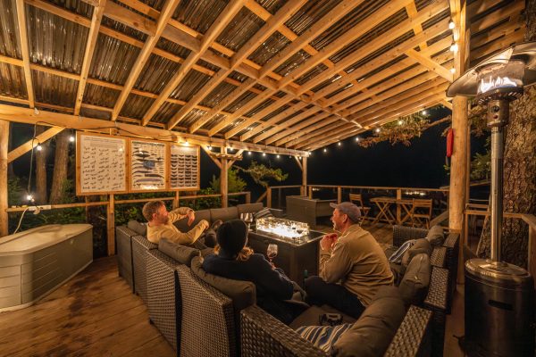
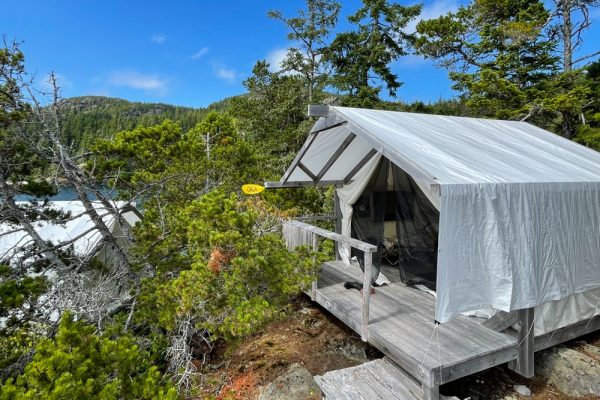
Our Whales and Wilderness Glamping site is our most comfortable camp. This camp has large cotton canvas tents with real beds, and private outdoor toilets with sinks. The tents are perched off the ground on cedar platforms spaced out throughout the forest for privacy. The beds each come with a mattress, white linens, and warm blankets. The camp also has multiple hand washing sinks, 2 hot water showers, a comfortable lounge and a hot tub both overlooking the ocean. At this camp we have the privilege of also having a private chef to cook the meals for your group. Explore this camp though our virtual tour.
Our Johnstone Strait camp is built atop of a rocky bluff straight across from the Robson Bight Ecological Reserve. This camp features a large kitchen and communal dining area, as well as a hot tub overlooking the Johnstone Strait. Comfortable amenities include large white cotton canvas tents on wooden tent platforms, complete with a cozy bed, bedding, and a pillow. You’ll have a designated composting toilet, as well as shared access to two heated outdoor showers.
Both of these camps offer spectacular paddling and wildlife viewing opportunities.
Due to the existing trip schedule for these camps, we are not able to be flexible on the trip dates. We can however customize these trip itineraries to your liking. To learn more about custom basecamp tours, check out our Private Tour page. For information on availability, please contact our office.
Custom sea kayaking EXPEDITIONS
We can arrange a custom sea kayaking trip to any place we go on our regular schedule such as Johnstone Strait, the Broughton Archipelago, the Great Bear Rainforest, the Nuchatlitz Marine Park, Desolation Sound and the Discovery Islands.
SOME ITINERARY IDEAS COULD BE ADDED TO YOUR CUSTOM TOUR:
- Boat based whale watching trip
- Grizzly bear watching trip
- Additional time for photography
- Additional time for hiking
- Salmon or rock fish fishing
- Yoga
We can also host family reunions, birthday parties, and family trips with young kids.
Please contact our office to get custom pricing for your unique adventure.